Ciudad Perdida
Ciudad Perdida
A Tayrona city built around 800 BC, Ciudad Perdida is reached after a 4 to 6-day trek through the Sierra Nevada de Santa Marta.
Ciudad Perdida, also known as Teyuna or Buritaca 200, is a pre-Columbian archaeological site located at approximately 1,300 meters altitude in the Sierra Nevada de Santa Marta, in northern Colombie. Built around 800 BC by the Tayrona civilization, it is accessible exclusively by a multi-day trek through the jungle, departing from the village of El Mamey. Access is regulated by authorized local operators and a guide is mandatory.
Why visit Ciudad Perdida?
Few archaeological sites in Latin America combine such antiquity with such demanding access. Ciudad Perdida was built around 800 BC, more than two millennia before Machu Picchu, and is accessible only on foot, after several days of hiking through humid tropical forest. You traverse the territories of the Kogi indigenous communities, direct descendants of the Tayronas and current guardians of the site. The trek thus combines archaeological, ecological, and cultural dimensions, within a massif designated a UNESCO Biosphere Reserve in 1986.
History of the site
The city was built around 800 BC by the Tayrona civilization, on a ridge of the Sierra Nevada, along the valleys of the world's highest coastal massif. It spans approximately 12,000 m² and at its peak was home to several thousand inhabitants. Likely abandoned upon the arrival of Spanish conquistadors, it remained hidden for more than 350 years, covered by tropical vegetation.
Its rediscovery dates to 1972, when treasure hunters (guaqueros) stumbled upon stone staircases leading to the site near the Buritaca River. Official excavations began a few years later. In 1986, UNESCO inscribed the Sierra Nevada as a Biosphere Reserve and World Heritage Site. Since the Tayronas left no written records, interpretation of the site relies on remains, Kogi oral tradition, and archaeological research.
What you'll see on site
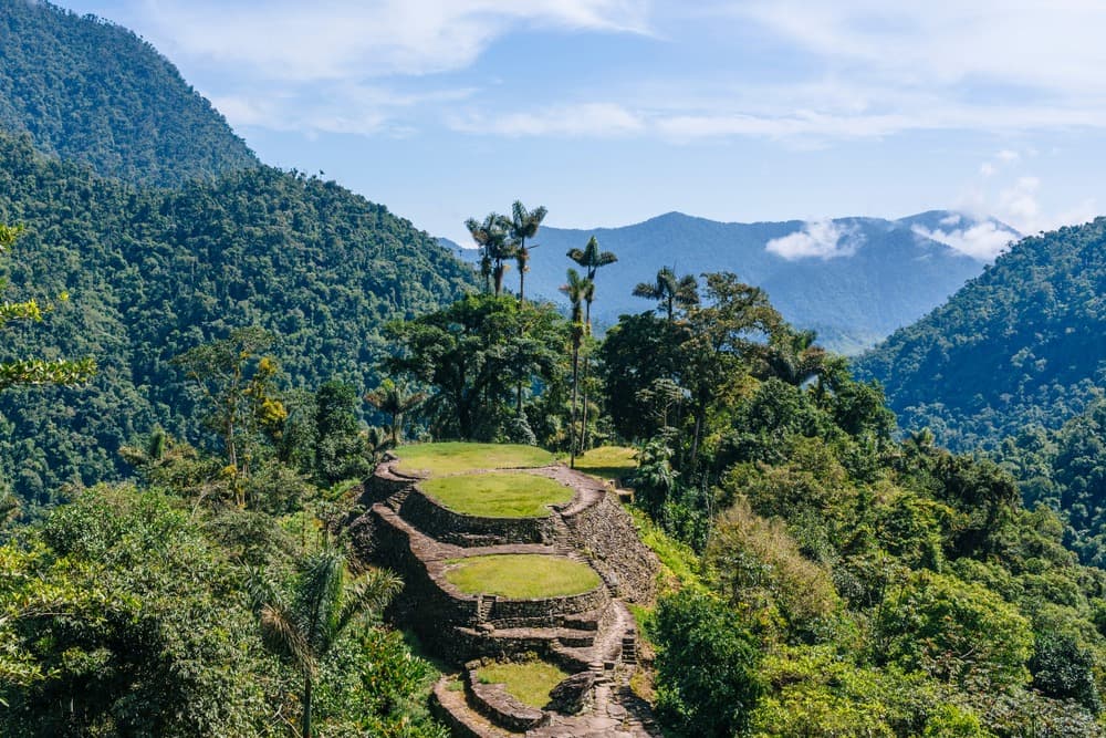
Ciudad Perdida comprises circular stone terraces tiered along the mountainside, connected by staircases, paved paths, and water channels. At the center, several ceremonial terraces were used for rituals and assemblies. Among the remarkable features:
- A map engraved in stone, whose interpretation remains debated (site plan or symbolic representation)
- The Mamo's chair, the Kogi spiritual guide's seat, still visible on site
- The final access staircases, approximately 1,200 narrow steps carved into rock, leading to the summit terrace
- Viewpoints over the canopy and surrounding valleys from the upper terraces
The Kogi oversee site visitation and certain areas are reserved for them. Visitors are asked to take nothing away and respect guide instructions.
The trek in practice
The trek departs from the village of El Mamey (Machete Pelao), approximately two hours by road from Santa Marta. The route covers roughly 40 km round trip, over 4 to 6 days depending on the package chosen. The itinerary alternates steep climbs, river crossings by wading, and passages through tropical forest.
The difficulty level is demanding but accessible to regular hikers. Heat (around 30°C) and humidity constitute the main challenge. Nights are spent in hammocks or bunk beds at camps managed by operators, equipped with water and meals. Near the camps, the Buritaca River and its waterfalls allow for cooling off.
Recommended equipment
- Backpack of 30 to 40 liters
- Already-broken-in hiking boots and sandals for river crossings
- Lightweight quick-dry clothing and a waterproof windbreaker
- Swimsuit, headlamp, water bottle with filter or purification tablets
- Insect repellent, sunscreen, hat
- Personal first aid kit
Access is reserved for authorized local operators and a guide is mandatory. Pricing is generally standardized among approved agencies and includes transport from Santa Marta, accommodations, meals, and entrance fees.
When to go
The region experiences a hot tropical climate year-round, with temperatures around 30°C. The dry season, from December to March-April, offers the best hiking conditions: less slippery trails, easier river crossings. The rainy season runs from September to November; showers are frequent in late afternoon and some passages may become difficult. The site generally closes for a few weeks in September to allow indigenous communities to perform purification ceremonies. Regardless of the season, plan for waterproof gear.
Access and organization
The main logistical hub is Santa Marta, on the Caribbean coast, connected by air to Bogotá and Medellín, and by road to Cartagena. From Santa Marta, agencies arrange 4x4 transfers to El Mamey (approximately two hours). There is no independent access to the site: going through an authorized operator is the only legal option. Several agencies offer daily departures in high season, in English, Spanish, or French.
What to combine with your itinerary
Before or after the trek, several stops complement an exploration of Colombie. In Medellín, Communa 13 and the Botero Museum offer urban and cultural contrast. In Bogotá, the historic neighborhood of La Candelaria concentrates the city's museums and colonial architecture. To extend your mountain immersion, Cerro Azul and its rock paintings constitute another remarkable archaeological stop.
Frequently asked questions
Frequently asked questions
The trek lasts 4 to 6 days round trip depending on the package chosen, for approximately 40 km of hiking from El Mamey.
No. Access to the site is reserved for authorized local operators and a guide's presence is mandatory for safety reasons and out of respect for the indigenous communities who are its guardians.
Good general physical fitness and experience with mountain hiking are necessary. The elevation gains, heat, and humidity make the effort demanding, but the trek remains accessible to regular hikers.
The dry season, from December to March-April, is most favorable. The months from September to November concentrate the heaviest rains, and the site generally closes for a few weeks in September.
Ciudad Perdida was built around 800 BC, well before Machu Picchu, which dates to the 15th century. It is among the oldest pre-Columbian archaeological sites in South America.
Plan your trip
Ciudad Perdida fits into a broader itinerary between the Caribbean coast, the Andes, and coffee valleys. To build a custom itinerary integrating the trek and the country's main highlights, explore our Colombie travel packages.
Interested in this visit?
We can include it in your personalised itinerary.